在火与冰的土地上进行测量
The Implementation of Geodetic Datums in Iceland: A Challenging Journey
Geodesists and surveyors in Iceland face considerable challenges due to the deformation effects of earthquakes, volcanic eruptions and glaciers on the geodetic networks. This article provides insight into the impact of this dynamic situation on the country’s geodetic datums over the past decades.
冰岛位于欧亚和北美构造板块的边界,它们以每年约10mm的速度漂移。板边界与目前位于Vatnajökull冰川下方的深层地幔羽相互作用。这会创造出复杂的裂谷和转变故障区域的模式,这是每个地球物理学家和地质学家的梦想,但对于地球员和测量师来说是一个挑战。由于板块构造,地球网络不断以类似的速度变形,随着人的指甲生长。地震和火山喷发可能会导致突然而严重的变形,在某些情况下,大量数米。这通常是在局部发生的,但有时会影响较大的区域,具体取决于事件的性质和大小。气候的当前变化也影响了大地网络。在过去的几十年中,冰岛的冰川一直在融化,不仅导致土地上升并因此垂直变形,而且还导致了一些水平变形。此外,还有一些局部人造变形的迹象,主要是由于地热力的利用而导致的土地沉降。
ISN93
1993年衡量了冰岛的第一个现代基于GPS的测量网络ISNET93,并于1997年发布了一个名为ISN93的新坐标系/数据。它取代了OmpoleteHjörsey55Datum。在接下来的几年中,进行了几次GPS调查以使网络致密,并将其与旧的Hjörsey55和其他本地系统联系起来。当在板边界处的区域和近距离工作时,很快就会明显看出,由于板块构造而导致的地壳变形引起了问题。当将ISN93点固定在板边界的两侧时,无法实现令人满意的网络调整结果。此外,2000年夏季,冰岛南部发生了两次幅度6.5的地震。由于这不是出乎意料,因此在ISN93法规中纳入了测量网络,应测量测量网络,并应公布新的坐标系/数据。至少每十年。
ISN2004 and problems with implementing a new datum
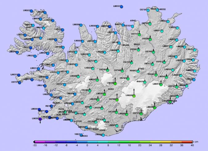
测量网络在2004年第二次测量。结果清楚地显示了板边界处的变形。它还显示了2000年地震的作用以及冰川熔化引起的垂直变形。值得注意的是,根据国际陆地参考框架(ITRF),冰岛以2厘米/年向北移动,北美板块以稍高的速度移动。分析变形时,通常会减去这种运动。
Adoption of the new datum ISN2004 failed. Many users had only just adopted ISN93 and were very reluctant to change over to ISN2004. Most GIS data did not accurately reflect the deformation between ISN93 and ISN2004. Developing grid transformations and getting them into GIS software also took some time. Moreover, some users argued that by the time they had adopted the new datum the NLSI would be set to publish another new one, so they preferred to wait for that one. Therefore, the ISN2004 datum is hardly ever used, even though it is the official datum of Iceland. But this does not change the fact that ISN93 is deforming – usually slowly and sometimes suddenly. As a result, survey results in the deformed areas are dependent on the benchmarks that are used as a reference. It is also complex to run a modern nationwide RTK-correction service in a constantly deforming but static coordinate system.
Therefore, it was clear that the next datum would have to address the deformation in order to extend its lifetime and ensure it was not obsolete by the time it was finally adopted by everyone. Experts from the National Land Survey of Iceland (NLSI) discussed this problem with colleagues from New Zealand who are dealing with a similar problem in terms of crustal deformation. One colleague told them: “The users want to have accurate coordinates, but they don’t want them to change”. To solve this predicament, NZGD2000 has been introduced in New Zealand as a semi-dynamic datum. The datum definition is kept frozen at a certain epoch in the ITRF. A velocity model is used to account for secular motions and patches are used to correct for earthquake deformation. The main benefit of this approach is that it can be treated as a static datum in many cases and applications, but the deformation can also be taken into account when needed. Another option would be to have fully dynamic datum in a global reference frame assigning velocities to every coordinate.
ISN2016:动态方法
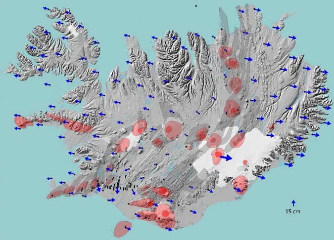
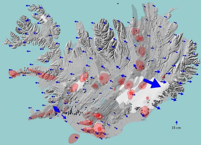
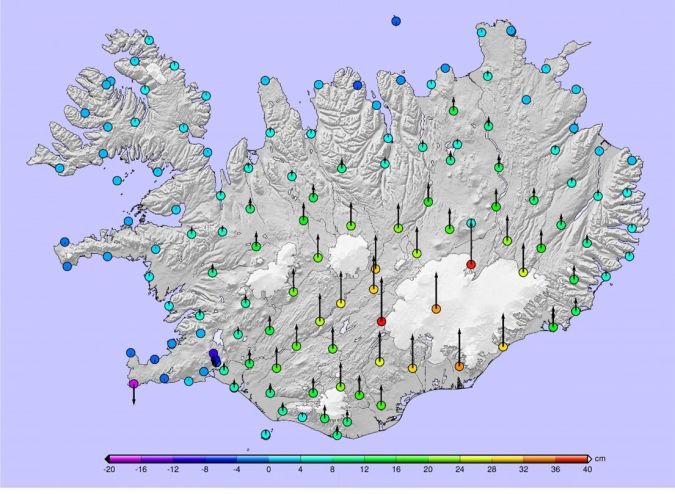
This was taken into consideration when planning the third measurement of the geodetic network, which was performed in 2016, and introducing the next coordinate system for Iceland. As expected, comparison with previous ISNET campaigns showed deformations due to plate tectonics and effects from the main geophysical events in the period from 2004-2016. An earthquake in south Iceland in 2008 caused more than 0.45cm deformation between the towns of Hveragerði and Selfoss, which are just 15km away from one another. The effect of the eruption in Holuhraun, north of the Vatnajökull glacier, in 2014-2015 was also very clear – not only in Kverkfjöll, where the eastward movement was 0.654m compared to 0.079m in the period from 1993-2004, but also in all the surrounding points. Jumps are visible in GNSS time series more than 150km away from the eruption site.
最有趣的结果是垂直变化。CGNSS时间序列在冰岛中部有一些迹象表明,2004年之后,陆地上升的加速度,比较在冰岛中部和东南海岸都证实了这一点。在Vatnajökull以南的地区,观察到的陆地升高约为2004 - 2016年30厘米,相比之下,在1993年至2004年之间仅约10厘米。
冰岛的新ISN2016数据是半动态基准。它的对应物是ISN_DRF,是根据eCecors CGNSS网络的坐标和站速度的任何时间对当前全局参考框架的局部实现。这种方法使验船师能够根据特定区域和所需的准确性选择适当的方法。随之而来的是,NLSI发表了转换网格,世俗速度模型的第一个版本和一个新的Geoid,以说明自冰岛垂直参考系统(ISH2004)以来,从2004年到2016年的垂直变化连接到同一时代,与ISN2004相同。。EPSG代码可用于ISN2016及其对较旧ISN系统的转换。名为Cocodati的在线转型服务已更新,并且在2021年底之前将最终确定所有用户的全国RTK校正服务。
Some external factors have been favourable. The increased use and development in PPP-RTK for surveying and precise navigation has created a greater need for precise velocity and transformation models since the results are always in the current global reference frame at the epoch of the observation. This means that more nations are working on these issues. For example, the Nordic Geodetic Commission recently launched a study project called DRF Iceland providing a fruitful forum to study various issues related to dynamic datums and time-dependent coordinates.
One of the key factors in the adoption of ISN2016 is to get transformations, velocity and deformation grids into mainstream geospatial software. The recent development of the Proj transformation software and GDAL that are running in the background of many geospatial software solutions has made it easier for the NLSI to distribute and implement its models. This offers the possibility of more advanced coordinate transformations and other coordinate manipulation than its predecessor. Even though it is not possible to do this directly in GDAL with simple command lines, this will hopefully soon be implemented in a mainstream and user-friendly geospatial software solution. Moreover, the velocity model and the transformation grids are also available in the latest versions of the Trimble Access and Trimble Business Center.
The ISN2016 is still not widely used in Iceland, but with most pieces in place it should be easier to adopt than ISN2004. Since NLSI is not going to introduce a new datum in 2026, the adoption is less time-sensitive. Surveyors and others working in the geospatial industry are generally positive towards ISN2016, but they need a nudge to get started. But overall, solving the geodetic issues that that follow a semi-dynamic datum is less challenging than adopting a new datum.
Volcanic eruptions on the Reykjanes peninsula
ISN2016的维护是一个正在进行的项目,雷克雅内斯半岛(冰岛西南部最西南部)的最新事件正在提出一些有趣的挑战。半岛有七个城镇,首都雷卡维克(Reykajvik)在其后院。Keflavík的国际机场位于雷克雅内斯半岛的北部,还有两个地热动力装置。板边界贯穿半岛,使其成为活跃的区域。小地震是相当频繁的,时不时发生。Reykjanes的最后一次火山活动在公元前800-1240座之间,但有迹象表明我们可能正在进入新时期。
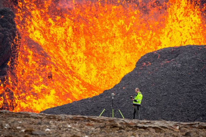
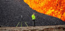
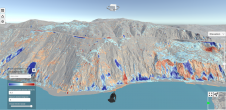
The unrest started in January 2020 with land uplift around the mountain of Þorbjörn close to the town of Grindavik and the Blue Lagoon. This was followed by two earthquakes of magnitude 5 in March and October 2020, then several smaller ones. On 24 February 2021 an earthquake of magnitude 5.7 occurred. Around 60,000 earthquakes followed in the subsequent weeks and INSAR and GNSS data showed clear signs of magma intrusion. On 19 March an eruption started in Geldingadalir, just east of Fagradalsfjall and 9km northeast of the town of Grindavík. The location of the eruption did not pose an imminent threat to the general population or infrastructure. However, since it was so close to inhabited areas and infrastructure, it was necessary to closely monitor the effusion rate, volume and area of the new lava in order to predict the threat if the eruption would continue for some time. This was done by frequently carrying out aerial surveys over the eruption to generate a DSM and orthophotos. This work involved close cooperation between the NLSI, the Iceland Institute of Natural History and the University of Iceland’s Institute of Earth Sciences.
NLSI的任务之一是在该区域建立地面控制点(GCP)网络,并确保为涉及空中调查的各方提供共同的参考系统,以进行响应和研究。显而易见的选择是使用ISN_DRF,并决定使用Epoch 2021.4。计算了由地球科学研究所(IES)安装的CGNSS站的坐标和靠近喷发现场的冰岛大都会办公室(IMO)的坐标,并监视了车站。如果发生任何大型运动,将修改坐标。尽管没有重大的动作,但2021年7月在熔岩下丢失了一个CGNSS站。在喷发期间进行了20多个航班任务,提供了有关进度的重要信息。
结论
冰岛动态的大地测量处对于测量师来说可能具有挑战性,但它也为有趣而令人兴奋的项目提供了机会。在冰岛维持地球网络是一项永无止境的任务。有必要实施一个具有时间相关的坐标,速度和变形模型的基准,以便与地理空间世界中的最新发展保持同步。也许最大的任务是使用户尽可能容易,这得到了Proj和Gdal等开放软件的最新开发。
喷发更新
自2021年9月24日以来,半岛上没有火山活动,但是由于经常在Fagridalur以北几公里处发生地震,但爆发的末端仍未被宣布。新熔岩已经覆盖4.85公里2with an estimated volume of 150 million cubic metres. But now that the unrest seems to have come to an end for a while, NLSI can start working on a deformation model of the event to be included as a patch in ISN2016.
进一步阅读
Make your inbox more interesting.Add some geo.
Keep abreast of news, developments and technological advancement in the geomatics industry.
Sign up for free