Technological Developments at Leica Geosystems - Interview with Mark Concannon
本文最初发表在地理学世界.
在去年年底,徕卡在英国庆祝第50届,GW有机会与Mark Concannon,Leica的Emea主任交谈。我们在处理数据卷,服务,无人机,培训和未来技术的发展方面进行绗视他。
地理学世界: Software has become ever more important over the last decade. Data volumes have accelerated with the arrival of laser scanning and high-resolution imaging. Surveyors often complain that the software seems to be playing catch-up with these high volume sensors. How has this affected R&D and technical support for Leica? Has the balance in terms of resources now switched from hardware to software?
Mark Concannon:The number of R&D engineers dedicated to software has significantly increased in recent years. This increase is to support the intelligence of core products to make field procedures ever more efficient, as well as to enhance workflows. Continued innovation requires significant R&D effort to be invested in both hardware and software development.
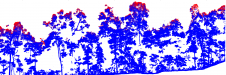
Some years ago, PC hardware was overwhelmed by the quantity of data collected with laser scanning, but today with inexpensive high-powered PCs processing of data is performed easily thanks also to smarter data-processing algorithms.
GW:供应商认为自己是“解决方案提供商”。但是,许多测量师通过选择用于处理传感器数据的独立软件来采用“混合和匹配”方法。你认为这是一个问题还是你试图与当前的练习谷物一起工作?
MC:It is important to offer a complete solution, and we are proud of being able to deliver a complete solution of products, software and after-sales services. However, Leica Geosystems also understands that local software is required to provide the best fit for local requirements, and actively works with local software developers to integrate their software into the Leica Geosystems’ solution. Examples include integration of the HeXML data format for optimal dataflow, and integration of the EpcA SDK to fully integrate point-cloud processing into local software packages.
GW:有人曾经说过他们在全站仪中寻找的三个最重要的事情是服务,服务和服务。你同意吗?
MC:One hundred percent. We’ve added 20 service engineers since last year. We have to be like the car industry: we want the whole-life relationship with the client. We’re a capital sales company. We want to look after the client and make sure he is happy with the purchase. We want to make sure the software is up to date, the instrument is fully serviced and servicing is scheduled. One of the reasons we’ve taken on more people is to ensure excellent service and now we and our partners can offer a 48-hour turnaround. We are responding to need and I believe about 80% of our engineers’ time is already booked for this year.
我们可以在一个单词中总结我们与客户享受的关系:伙伴关系。这是我们对所有客户的承诺,这是一个真正的伙伴关系,其中包括全球的全球积极的客户服务支持和服务,随时随地。
我们提供独特的售后服务的其他领域是通过使用先进的规划系统,使客户能够实时查看他们的产品,通过MyWorld客户互联网门户服务。
我们的座右铭是“必须正确的时候”,我们为自己和我们获得的公司应用它。188asia备用网址一个方面是我们推出他们的新产品必须准备好。如有必要,我们将推迟推出以确保产品已准备就绪。我们最近推迟了六周的产品发布,这是这一原因。
GW: While it’s difficult to crystal-ball gaze into the future when so much is dependent on economic prosperity, what technology developments would you expect or would you like to see over the next ten years?
MC:The release of the Nova MultiStation saw the integration of angular and distance measurement, imaging and precise 3D scanning with GNSS connectivity. We see integration of technologies as a continuing process.
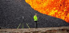
在测量师的工具包中,成像将变得明显更重要,并且您将能够用图像做更多。我们现在使用总站的图像,扫描将是基于的更多图像。关键是所有这些数据如何管理到客户端可以使用的可交付状态。我们将沿着数据的虚拟现实道路移动丰富的文件。
技术发展将专注于改善客户工作流程,从而提高生产力。随着更多产品在现场启用互联网的信息,通过云提供的服务将变得越来越重要。云服务包括在线支持,数据交换和图像内容作为服务(CAAS)。
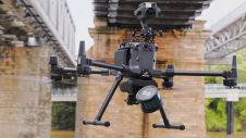
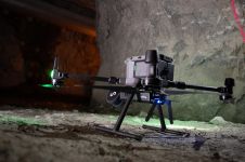
GW:Leica最近收购了UAV供应商。您目前的产品看起来相当昂贵,反对验船师和其他人可以相对容易地创建自己的“选择和混合”系统的最具竞争力的市场。你有计划回应这个吗?
MC:aibotix是一种可靠的高端解决方案,我们可以在空间中准确地定位,它可以携带相机,激光扫描仪和高光谱传感器。与您自己的DO-IT的选项相比,这是昂贵的,但我们相信有专业级无人机的市场,公司将作为生产工作流程的一部分运行,由我们级联支持和服务支持188asia备用网址网络。我们将Aibotix视为这个市场的未来。
World domination of the drone market is impossible for us and we are not interested in the consumer market. We see big opportunities in civil engineering and are already selling Aibots in Scandinavia where they are doing volume metrics for construction progress monitoring. But the market is still developing. For example, Easyjet is now using UAVs to inspect its aircraft.
GW: We often hear professional surveyors complaining that they face stiff competition from firms without qualified survey staff which have acquired advanced technology like laser scanners or GNSS. The practice of selling to inexperienced personnel can be self-defeating in terms of growing the market for these complex technologies. What do you do to educate users?
MC:You’ll never overcome the problem in the unregulated UK. In other countries, they only have qualified people working in cadastre systems. The UK is relatively unique. The professional bodies in the UK have tried hard to create standards but we’ll always have the issue of training because the simpler the equipment gets, the less skilled you need to be to utilise it, which is a selling feature in some cases. In the long-term, the quality of the deliverable given to the client from whoever does the work will dictate the next piece of work. I’m against work being given on a tender basis because you can never measure value. It’s about the perception of value. You can never get the same quality product from the four or five people who tender.
我们今天的许多用户不是测量专业人士,但仍然可以轻松使用我们的产品。一个示例是图标现场产品,专注于图形元素,以确保非专业人员可以快速学习和实现构建和施工应用。
GW:您的竞争对手之一在多映像传感器和GNSS周围开发了一种地形测量系统,以提供摄影测量数据。您是否有类似的发展计划?
MC:Combining imaging and positioning technologies is not new to Leica. For several years, imaging technology has been combined with total stations. Through partner software, it has always been possible to extract coordinates from overlapping images. With the next release of Leica Infinity office software, deriving coordinates from images will also be possible. In cases where positioning the total station requires GNSS, the SmartPole or SmartStation set-ups can be employed.
This article was published in Geomatics World March/April 2015
Make your inbox more interesting.Add some geo.
Keep abreast of news, developments and technological advancement in the geomatics industry.
Sign up for free