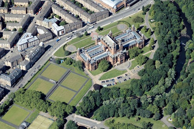
苏格兰城市添加到Metrovista 3D城市阵容中
空中地图公司布鲁斯基国际(Bluesky International)将爱丁堡和格拉斯哥添加到了Metrovista 3D城市模型的日益增长的覆盖范围内。Metrovista数据使用先进的空中传感器和高点密度激光雷达一起捕获垂直和倾斜的图像,Metrovista数据在智能城市应用中变得越来越流行。
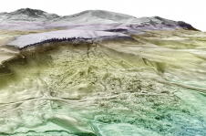
Metrovista数据提供了城市环境的地理准确和详细的3D表示,已经为包括城市设计,国防和安全建模,保险评估以及公用事业和电信计划等应用程序提供了见解。
Analysing the Impact of New Developments
布鲁斯基国际(Bluesky International)销售总监拉尔夫·科尔曼(Ralph Coleman)评论说:“我们变得越来越多地城市化,这给那些负责管理这种环境并在其中提供服务的人带来了压力。”“为了做出知情并加入的决定,不仅必须可视化我们的城市景观的外观,而且要能够衡量,建模和分析新发展的影响。”
“使用Metrovista 3D模型我们可以可视化现在并模拟未来,从而对结果的影响和引人入胜的沟通进行分析,所有这些都具有高度的信心,而无需离开办公室。”
混合空中映射
Bluesky captured the urban centres of Edinburgh and Glasgow in 2021 and the data is now available as ultra-high resolution 5cm aerial photography together with 16ppm Lidar. The data is also being processed to create a fully rendered mesh model suitable for use in a range of GIS, CAD and modelling software packages.
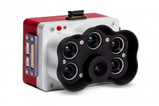
这Leica CityMapper传感器用来捕获Metrovista数据,是世界上第一个混合机载传感器之一。第一台相机在RGB和近红外捕获了垂直的或Nadir真实的矫正摄影,而其余四个相机则提供完整的360度倾斜覆盖范围。结合来自集成高密度激光雷达的数据,这允许生产,最少的手动相互作用,准确且详细的全市网格模型。
独立数据集和处理数据
Bluesky, known as the aerial mapping company in the UK with complete coverage of high-resolution imagery and height data of England, Wales, Scotland and the Republic of Ireland, was the first to exploit the power of this new technology in Europe. Launched to market as MetroVista the Bluesky data is available as standalone datasets (vertical/oblique/Lidar point clouds) or processed data (digital terrain or surface models [DTM/DSMs] or fully rendered 3D mesh models).
Since acquiring the first CityMapper in Europe, Bluesky has captured more than 1,500sqkm of MetroVista data to date, including of Birmingham, Brighton, Bristol, Cambridge, Leicester, London, Nottingham and Oxford, plus many more.