Multi-disciplinary Trend Detection, Analysis and Forecasting from Aerial Film Archives
2022年4月15日
Only a small fraction of the information content in aerial films has ever been recorded on paper maps, most of which are inaccessible. The use of artificial intelligence (AI) to fully automate the process of information extraction from imagery will soon unleash the true value of this information by enabling the creation of land cover maps of all the world’s countries stretching back to the 1930s.
From the 1930s to about the year 2000, much of the world was captured at regular intervals on high-resolution aerial film using aerial mapping and reconnaissance cameras, by national mapping organizations, defence organizations and private mapping companies. During that time, the Earth has been transformed by massive industrialization and urban growth. The Earth’s population increased threefold from two to six billion people, tens of millions of kilometres of roads were constructed, billions of houses were built, global GDP increased fourfold, and large areas of forest and grasslands were transformed into agricultural fields and towns.
These changes to the Earth are recorded on millions of rolls of aerial film that mostly lie locked way in archives and remain inaccessible. Unfortunately, due to past technical limitations and laborious manual feature extraction, only a small fraction of the information content in these films has ever been recorded on paper maps, and most of these are no longer accessible and not digitized. Many of the films are deteriorating, or even worse are being disposed of as the storage costs are considered too high. However, these films record the heritage of our changing world and are a highly valuable resource if they can be accessed.
This has now all changed. It is now possible to use artificial intelligence (AI) to fully automate the process of information extraction from imagery. If a human operator can identify a feature, then AI can do so too as long as it is provided with sufficient training datasets. The deep learning models are advancing rapidly, and techniques such as transfer learning are significantly reducing the number of training datasets required.
These land cover maps will provide real statistics on how the planet has changed. Moreover, creating multiple temporal data points will enable us to determine accurate trends in various domains and hence to better predict the consequences of future development measures. These data points in time can be correlated with other measurements to better understand the cause and effect that humans have on the environment, as well as the changes that must take place to avert a global environmental disaster.
土地覆盖图also enable simple change detection and anomaly detection for the identification of features currently lost to more recent human development or natural erosion processes. Further, review of the imagery provides irrefutable evidence that is not available in older paper maps which are based on human interpretation and biases.
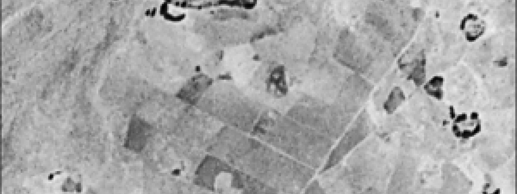
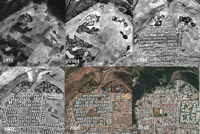
A single image in time provides a snapshot of the world. That in itself is fascinating. We can identify things that have been lost in time and draw accurate conclusions on aspects such as property boundaries, forest extents, levels of infrastructure, and the location and structure of buildings that may no longer exist. A series of pixel-aligned georeferenced images tell an even greater story. The significance is created by the time-lapse effect, similar to a movie clip composed multiple of images, highlighting gradual movement and changes over time. Therefore, observing temporal orthoimages enables us to instantly identify objects that have changed or been displaced, even when in the displacement has been too slow to be noticed on site in real time. The time-lapse effect allows us to identify developments at an early stage, when we can still identify the cause and consequently have the opportunity to respond to the trend. Waldo Tobler’s first law of geography states that “Everything is related to everything else, but near things are more related than distant things”. The definition of “near” is not only spatial, but also applies to time. Everything affects everything: an axiom!
卫星图像改进
Space-based imagery has been available since the 1970s. With the exception of the Corona Satellite photography imagery (about 1960-1970) that had approx. 3m resolution and was kept highly secret for about 30 years, the only wide-area satellite imagery coverage was from the Landsat programme which at that time had 60m resolution. Most aerial imagery between the 1930s and 2000 was captured at sub-metre resolution, and cities often at decimetre resolution.
The resolution of commercial satellite imagery has improved immensely since then. In 2000s, 1m resolution imagery became accessible, and today accurate global 1m resolution imagery is available along with accurate digital terrain models. The massive volumes of high-resolution satellite and digital aerial imagery is providing us with an accurate definition of our world today, but to really understand the trends we need to look back at the changes that have taken place over many decades. The availability of such accurate high-resolution basemap and digital terrain models greatly facilitates the georeferencing and orthorectification of the older aerial imagery to enable suitable simple comparisons.
Sample selection of georeferenced multi-temporal aerial images of Munich
GeoDynis revolutionizing the accessibility of aerial film archives by developing highly advanced photogrammetric aerial film scanners capable of transforming these aerial films into quickly accessible, accurate digital images that maintain the full information content. With PromptSCAN, the conversion speed is now 50 times faster and a magnitude cheaper than was previously possible. In addition to scanning,GeoDyn还提供了高效的工作流程,以准确地进行这些图像,以创建时间图像图和提取信息以实现变化的识别和量化。
GeoDynwas founded by a team of photogrammetrists. The vision is to unlock the information recorded in aerial film archives around the world and convert it into temporally sequenced maps so that humanity can fully understand the Earth’s geopolitical, climatic and industrial development over time. Between them,GeoDyn’semployees have over 200 years of experience in the aerial survey industry. The company provides full-service aerial film conversion, georeferencing and information extraction. In addition to the development of high-speed aerial film scanners,GeoDynhas developed technologies that enable the rapid and accurate conversion, georeferencing, rectification and delivery of aerial imagery.
As an Esri Gold Level business partner,GeoDynassures full integration with ArcGIS. All images become accessible as both temporal base maps and dynamic image services, enabling the full information content of the imagery to be accessed in a wide range of applications for visual interpretation, automated feature extraction using machine learning, and data analytics.
More info
A sample selection of georeferenced multi-temporal aerial images can be viewed atwww.geodyn.com.
Download PDF or Print
Download this article as a print friendly PDF and receive our weekly overview of the most important geomatics news and insightful articles and case studies.
Sharing this article
当然我们鼓励你分享这篇文章with your peers if you enjoyed reading it. Copy the URL below or share it on your social media of choice.
This site uses cookies. By continuing to use this website, you agree to ourCookies Policy.Agree


