Applanix介绍了用于移动映射的下一代OEM解决方案
Trimble公司Applanix已宣布了Trimble AP+ Land GNSS惯性OEM解决方案,以便在土地移动映射应用程序中为地理发起传感器和定位车辆进行准确,健壮的位置和方向。
该解决方案使用户能够准确有效地跟踪和监视车队,生成高清(HD)地图和3D型号,或者充当高级驾驶员辅助系统(ADAS)测试的参考解决方案,即使在GNSS环境中最具挑战性的情况下也是如此。
挑战GNSS信号环境
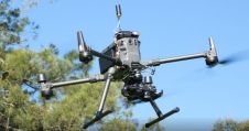
The Trimble AP+ Land is a comprehensive tool for land vehicle applications that is small enough to easily integrate into the most compact mobile mapping systems. It is also compatible with virtually any type of mapping sensor, including single or multi-Lidar systems, video cameras, photogrammetric and panoramic cameras and other similar sensors.
可配置来满足mapping, positioning and direct georeferencing (DG) accuracy demands of mapping and positioning applications in challenging GNSS signal environments, the Trimble AP+ Land solution features, amongst others: Applanix IN-Fusion+ GNSS-aided inertial firmware with Trimble ProPoint GNSS positioning technology, dual embedded survey-grade GNSS chipsets that can receive multi-frequency and multi-constellation signals and dual custom-designed inertial measurement units (IMU).
可扩展定位解决方案
Applanix的惯性技术,空气和土地产品总监Joe Hutton说:“我们采用了Applanix惯性和三重GNSS技术的最先进的功能,并将其包装成一个功能强大的紧凑型和多功能解决方案,可针对移动映射和定位应用进行了优化。”“我们通过开发灵活且可扩展的定位解决方案(例如AP+ Land等)来致力于客户的成功。”
Trimble AP+ Land OEM解决方案得到了行业领先的Applanix Pospac MMS后处理软件的全面支持,该软件具有Trimble Centerpoint RTX RTX后处理,用于全球范围,无需基站。这些功能使集成商成为生产高效的土地移动映射系统的合适解决方案。
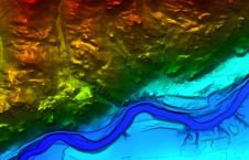
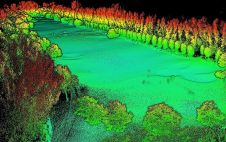
For Lidar integrators, the Trimble AP+ Land OEM is compatible with the POSPac MMS Lidar QC tools. SLAM technology computes the IMU to Lidar boresight misalignment angles and also adjusts the trajectory to achieve the highest level of georeferencing accuracy in the generated point cloud.