通过陆地激光扫描仪改善地质力学分析
坚如磐石?
People often describe something hard and immovable as ‘solid as a rock’. But rock does not always live up to its reputation. Depending on its characteristics and local conditions, sections of rock may slip, slide, crumble or deform, with potentially serious consequences. Geologists study the geomechanical properties of rock masses to understand how they may fail. This is traditionally done by measuring the characteristics of the rock mass discontinuity sets by climbing the rock face or by using photogrammetry, but terrestrial laser scanning (TLS) has caught the attention of geologists as being a safer and more effective method. Read more about the use of TLS for geomechanical analysis in the Italian Alps.
(由意大利都灵Imageo的总裁兼联合创始人Andrea Tamburini博士)
Peaking at over 4,000 metres in height, the Matterhorn is a famous landmark on the border between Switzerland and Italy. Climbers ascending the summit of this Alpine mountain along the conventional Italian route on the south-west ridge usually start at the Carrel Hut, a small building perched on a cliff. Unfortunately, melting permafrost has weakened the rock mass of the cliff, causing regular rock falls which occasionally even lead to closure of the route. This hazardous situation prompted the Fondazione Montagna Sicura (Safe Mountain Foundation, FMS) to ask the Turin University spin-off IMAGEO to analyse the nearby rock and determine the danger to the route and the hut. This activity was initiated within the framework of the PERMAdataROC Interreg III project in the summer of 2008. Surveying the Matterhorn is now done on a regular basis. Initially it was one of IMAGEO’s early chances to test TLS for this application, but the Alps remain an interesting research location for further improvement of the technology today.
TLS的好处
现场调查相比,主要的好处using TLS is its range. Instead of having to climb around unstable rocks, researchers examining the unstable part of the Matterhorn around the Carrel Hut can set up the laser scanner (the Optech ILRIS TLS in this case) 400 metres away on the crest of the considerably safer and more accessible Testa del Leone. The TLS also proves superior to traditional photogrammetry thanks to the inherently 3D nature of its laser point cloud. The first step of rock mass geomechanical characterisation is to measure the geometric discontinuity parameters (dip and dip direction) in 3D, and a TLS can quickly cover the entire region of interest with millions of 3D laser points. Conversely, to derive 3D data from photogrammetry, one needs to shoot the mountain area from multiple angles and merge the image sets using triangulation software. This technique can be useful, but is much less accurate than TLS data and requires operators to set up reference points on the rock face in order to scale the 3D model, as photogrammetry is inherently dimensionless. In this particular case the only possible vantage point is the Testa del Leone, thereby precluding the use of terrestrial photogrammetry. Recent experiments have been carried out with cameras mounted on unmanned aerial vehicles (UAVs) to overcome these issues, but they cannot fully replace TLS surveys because UAVs generally have far shorter ranges and cannot easily operate in the windy and high-altitude conditions of the Alps. In favourable conditions, however, both methods can be combined successfully to improve the overall coverage since a UAV can capture rock ledges that a ground-based TLS may miss.
倾角
与往常一样,调查只是努力的一半。有了原始的3D数据,需要提取岩石质量不连续性的几何特征,以识别山的弱点。首先感兴趣的项目是倾角和倾斜方向,因为它们显示了潜在的不稳定岩石量及其可能的滑动机构的位置。Terranum coltop3d用于根据周围点确定每个点的斜率的局部方向。Rocscience DIPS用于将数据投影到2D立体声上。随后对数据的统计分析有助于对测量值进行分组并获得主要不连续集集的方向。
Rock fractures
除了倾角和倾斜方向,这是艾尔so important to understand the distribution of fractures in the rock mass because the combination of discontinuity sets creates removable blocks of different sizes and shapes. More fractures generally make for weaker rock, but geologists need to consider several other variables including their spacing, length and intersection. For the Matterhorn survey, each of these variables was measured manually in the past in a tedious and time-consuming task. This task has now been automated thanks to third-party software and custom algorithms. The first step is to turn the point cloud into a mesh using JRC 3D Reconstructor and then use a custom semi-automatic tool to detect the main fracture traces. These traces are then turned into polylines and exported as a GIS format before grouping them into discontinuity sets based on their orientation. Unfortunately, there is little off-the-shelf software available to map the frequency, spacing and intensity (P21裂缝以及基本岩石体积(VB)和体积关节计数(JV)。因此,ESRI的Arcpy和GDAL(一组开源空间库)已用于开发自定义算法以执行所需的任务。最后,将有关浸入和断裂的所有信息组合成斜率质量评分(SMR)图,这是通常用于岩体分类的索引。
改善自动化
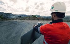
到目前为止,传递的数据对FM在支持补救工作和监视解决方案方面非常有用。基于这一成功,每年仅在阿尔卑斯山就进行了五到七个TLS调查。每项调查都有助于进一步提高使用各种软件工具的数据处理和分析自动化的效率。现在,TLS和相关的软件工具也用于山脉以外的其他应用程序,例如沿着道路和铁路绘制岩石坡度稳定性。例如,已经对矿山操作员进行了地下测试调查,以证明TLS适合调查隧道面孔。调查速度在这里引起了重大关注,因为在调查过程中必须暂时停止采矿活动。通过将Ilris TLS安装在皮卡车上以从隧道到隧道开车来降低岩石面所需的时间;只需七分钟即可扫描每个隧道面的面孔。由于在使用自动化工具进行调查后,由于还在现场对数据进行了后处理,因此仅需要两到三个小时才能产生最终数据,矿床所有者都同意,该数据与他们常规的摄影测量方法一样准确。
Effective new approach
The results of the Matterhorn project and the underground mine tests have proven that TLS is an effective new approach for analysing the stability of rock mass in several contexts, both with static and kinematic surveying. This helps in planning more detailed investigations, designing protection works and defining the most appropriate strategy to monitor slope deformation in the future.
Andrea Tamburini
Dr Andrea Tamburini is a geologist with a PhD in geomatics. He has led several projects regarding landslide and glacier hazard assessment and monitoring. From 1987 to 2007, Tamburini worked with various ENEL Group research companies (ISMES, CESI). Since 2007 he has been president and CEO of IMAGEO Srl, a spin-off company of Turin University. His main expertise regards the use of geomatics for the study and characterisation of unstable slopes at both local and regional scale, as well as the geomechanical characterisation of rock cliffs, open-pit mine slopes and tunnel faces.
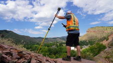
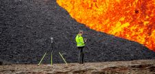
数字1,,,,South-west ridge of the Matterhorn as seen from the survey point (Carrel Hut visible in the centre).
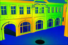
数字2,斜率方向分析(左)和Matter Horn上主要不连续性集的方向。
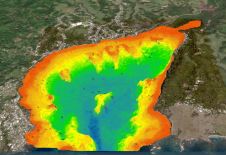
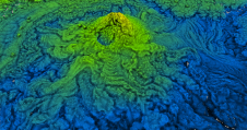
数字3,,,,Automatically generated slope mass rating (SMR) map of a slope near Courmayeur in the north-western part of the Alps (red indicates areas that are less stable).
数字4,,,,Tunnel face (left) and automatically generated map of its joint orientation (right).