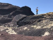
在东部加勒比海的空中激光雷达调查如火如荼
加勒比社区气候变化中心已开始在加勒比海开发银行(CDB)的十个借贷成员国(BMC)的激光调查中:安提瓜和巴巴多,巴巴多斯,巴巴多斯,贝利兹,圭亚那,墨西哥岛,苏里南,圣卢西亚,圣基亚特,圣基特斯,圣基特斯和尼维斯,圣基特和尼维斯,圣基亚特,圣基亚特,圣基亚特和内维斯,圣基亚特,圣基亚特,圣基亚特,圣基亚特,圣基亚特,圣基亚特,圣基亚特,圣基亚特,圣基亚特,圣基亚特,圣基亚特,圣基亚特,圣基亚特,圣基亚特,圣基亚特,圣基亚特,圣基亚特,圣基亚特,圣卢西亚,圣基亚特,圣基亚特,圣基亚特,圣基亚特,圣基亚特,圣基亚特,圣基亚特,圣基亚特和内维斯Vincent和Grenadines,Trinidad和Tobago,Turks和Caicos。
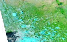
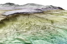
这些激光调查是多年的远见,努力和奉献精神的高潮,以提供负担得起的地理空间,高分辨率地形和测深数据,使决策者能够使用基于证据的方法计划其气候弹性发展计划和项目。LIDAR计划的这一阶段于2022年3月31日在巴巴多斯开始。
建立一个地理空间数据集,以实现可持续发展
通过从最近在最近的国际发展局(USAID)筹集资金的情况下,获得了能够获得测深和地形调查的第一个能够获得测深和地形调查的首个以加勒比海为中心的最先进的激光雷达系统的收购。总结的气候变化适应计划(CCAP)。CDB为CCCCC在其BMC中进行试点测深和地形激光雷达调查,以证明LIDAR数据在气候弹性开发中的实用性,而意大利政府通过生态过渡部(MITE)(MITE),以前是意大利环境部,土地,土地。SEA(IMELS)向CCCCC提供了赠款支持,以进行必要的基础,以告知LIDAR调查计划。
加勒比海激光元计划旨在建立一个关键的高质量地理空间数据集,以使可持续发展能够弹性,以使气候变化和海平面上升,支持BMC中的演示类型的测深和地形调查的行为,训练BMCS数据最终用户,并增强bmcs数据最终用户,并增强中心内提供数据管理服务的能力。
激光雷达调查为加勒比地区的利益
t机载数据采集已经成为可能hrough a public-private partnership via an agreement with Maya Island Airlines out of Belize initially, and subsequently, through a Framework Agreement with Leading Edge Geomatics (LEG) out of Canada. “Despite many delays and challenges caused by the COVID-19 pandemic, the CCCCC is proud and excited to be able to commence this historic Caribbean Lidar program across the Region that will contribute high-quality geospatial data to Member States to inform their climate resilient development plans and disaster risk reduction strategies,” says Dr Colin Young, Executive Director of the CCCCC. “The fact that the CCCCC now possesses Lidar capacity is a testament to the vision of Dr Kenrick Leslie, former Executive Director of CCCCC, the Centre’s resolve and the strategic partnerships with donors such as the USAID, Government of Italy, the CDB, and the participation of the private sector. With this capacity, resident in the Region, we look forward to working with CARICOM Member States and the private sector to deliver high-quality Lidar surveys and products at reasonable and affordable costs for the benefit of the region and our Caribbean people,” concluded Dr Young.
该计划直接介绍了该中心的核心任务,即收集和使用气候数据和信息来为整个地区的基于证据的决策提供信息。CCCCC的董事会,管理层和员工“最感谢我们的捐助者的支持,合作伙伴的承诺以及我们团队在使该计划成为现实的决心。”