无需基站的无人机测量的准确地搜索
Klau Geomatics专门从事后处理的运动学(PPK)直接地理发射技术,已宣布其新的无人驾驶飞机(无人机)(UAVS)的新的No-Base-Station高临界力地理质量解决方案。这种创新的新解决方案是Klau Geomatics与Hexagon的地球系统部门密切合作的结果,使用户能够在不运行本地GPS接收器的情况下进行无人机测量项目,从而产生高智能3D调查数据。
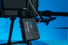
除了准确性之外,这是我们地理发行解决方案的最重要特征,还简化有效的工作流程。用户不需要任何调查设备来放置地面控制点(GCP),甚至为其PPK放置本地基站。Klau Geomatics的技术总监Adam Chabok说,他们可以收集精确的地理专用无人机数据,甚至可以使用其无人机捕获地面检查点。有了简化的插头有效负载,该系统可以轻松地连接到任何无人机或载人飞机上。
HXGN SmartNet业务总监Robert Martin说,HXGN SmartNet提供了完美的参考站基础架构,并通过X-POS技术启用自动访问。这是一个很好的示例,该应用程序受益于快速工作流程,在该应用程序中,用户可以始终依靠HXGN SmartNet Rinex数据存储库,该数据存储库由全球4,500多个参考站组成。通过即时访问所需的数据文件,可以消除数据处理中的任何延迟。
简化的高精度无人机测量
Klau Geomatics was founded in 2008 by experienced survey engineers with decades of knowledge in GPS systems, surveying, geodesy, photogrammetry and geospatial platform development. The KlauPPK georeferencing system was introduced in 2015 and has continued to advance with innovative product developments. The No-Base-Station solution is an outstanding example that enables any UAV carrying the KlauPPK system to collect and deliver highly accurate mapping data. Within 10 minutes of landing, the GPS correction data is available via the KlauPPK post processing software to geotag photos in any local or global coordinate system.
更有效和富有成效的映射
借助KLAU PPK直接地理发电系统,无人机可以通过将侧面重叠降至40%,从而在一次飞行中覆盖较大的区域。作为DJI无人机PPK软件包的一部分的预校准相机,数据处理的时间大大减少。摄影测量处理软件具有准确的摄像机校准,位置和态度数据,以加速空中三角调节过程,以减少照片的方式获得更好的结果。
建设和我的网站s often use customised local coordinate systems and datums. Data produced by a typical UAV needs to be transformed to the local site frame of reference to be useful. This process is managed in the KlauPPK solution to allow users to collect accurate aerial data in any local or global coordinate system without external coordinate conversion software. KlauPPK enabled UAVs can be used to collect ground control points, similar to a survey grade GPS receiver, and automatically calibrate to the local site frame of reference.
兼容性和可用性
The KlauPPK solution is compatible with most DJI UAVs or other fixed wing, multirotor and custom UAVs or manned aircraft. Hundreds of professionals worldwide have successfully adopted this technology in their workflows with exceptional accuracy, reliability and efficiency. The No-Base-Station solution is currently available in Australia and Europe and will soon be deployed in North America.
For more information, please visitwww.klauppk.comorhxgnsmartnet.com。


