Paracosm Partners up with Geo-Plus to Expand Land Survey Offering
This article was originally published inGeomatics World.
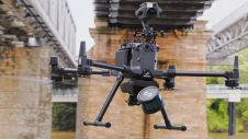
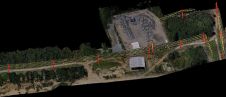
Paracosm has announced a partnership with Geo-Plus to offer the VisionLiDAR point cloud processing software in a bundle with the PX-80 handheld scanner. Joining forces means both companies now offer an end-to-end 3D mapping workflow for a variety of applications.
“We are delighted to offer this software to ourPX-80customers” says Amir Rubin, Paracosm president. “The versatileVisionLiDAR作为标准点云处理工具作品 - 许多工作流程中的关键需求 - 但还包括特定应用的全面功能,如地形生成,城市资产提取和树提取。它允许我们提供真正完善的3D映射解决方案,以满足测量和其他行业的要求需求。“
“Paracosm’s robust handheld mapping technology is an ideal complement to our software,” says Wilfrid Beaupre, CEO of Geo-Plus. “Bundled together, they provide users with a variety of powerful, cutting-edge workflows – helping them to generate quality 3D deliverables in almost any environment.”
To kick off this new partnership, Paracosm and Geo-Plus will host an informationalwebinaron 12 March at 3PM EST. Called “How the Paracosm and Geo-Plus Partnership Streamlines Your 3D Land Survey Workflows,” this webinar will demonstrate a variety of general and industry-specific workflows, including the benefits of handheld Lidar for outdoor capture, point-cloud processing, volume analysis for material stockpiles and gathering tree DBH measurements for forest inventory.
About Parascosm
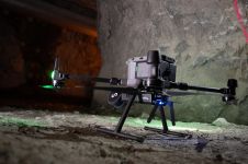
Paracosm develops Lidar capture and visualization technologies for professional 3D mapping applications. The most demanding users in AEC, facilities management, forestry, visual effects, and more are using the PX-80 handheld Lidar scanner to capture high resolution, colourized point clouds in virtually any indoor or outdoor space – and develop new workflows to transform their businesses.
让你的收件箱更有趣。Add some geo.
Keep abreast of news, developments and technological advancement in the geomatics industry.
免费注册