芬兰的第一个在埃斯波注册的3D财产
本文最初发表在地理学世界.
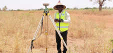
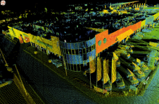
The first 3D property in Finland has been registered in Keilalahti, Espoo, with a new parking plot parcelled underneath the current plot. Residential buildings of 40 storeys have been planned for the area. The act on the registration of 3D property entered into force on 1 August 2018. The first 3D property was entered in the cadastral register on 9 January 2020. The formation of 3D property requires changes in the local detailed plan, provided that the valid local plan does not enable 3D plot division.
3D物业形成的目的是澄清房地产的所有权,并制定准备协议的过程,完成房地产交易,并更容易分配房地产税。
The 3D property system has been under development since 2006. On 1 April 2015, Arvo Kokkonen, director general of theNational Land Survey of Finland(NLS), appointed implementation and deployment projects to carry out the changes required by the 3D property system in NLS data systems. These were preceded by a definition project, which was completed in 2014.
Years of Cooperation Behind the New System
The new 3D property system has been built in close cooperation between NLS, municipalities and the Association of Finnish Municipalities. Members of the implementation and deployment project team were the cities of Helsinki, Espoo and Tampere and the Association of Finnish Municipalities. The deployment project coordinated and prepared the progress of the legal amendments required.
Significant changes have been made in the data systems of municipalities to enable 3D plot divisions. Municipalities were independently responsible for these changes.
发展总监PEKKA HALME主持由NLS领导的项目的转向小组。责任领域主任Mikko Peltokorpi担任实施项目的项目经理,高级专家PaavoHäikiö担任部署项目的项目经理。
The development of the 3D property system started in 2006 when the Ministry of Agriculture and Forestry set up a large-scale working group. Its members were the Ministry of the Environment, the Ministry of Justice, NLS, the Association of Finnish Municipalities, the City of Helsinki and the Helsinki University of Technology (currentlyAalto University).
让你的收件箱更有趣。Add some geo.
Keep abreast of news, developments and technological advancement in the geomatics industry.
免费注册