LIDARSurvey over Ancient Maya City
Improving Archaeological Maps and Identifying Hidden Structures
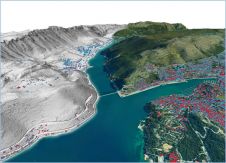
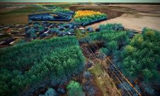
The ancient Maya site of Copan, Honduras, was captured during an airborne Lidar survey in May 2013. The resulting products are accessible through 2D and 3D WebGIS tools and enable archaeologists to collaborate online. This interdisciplinary project, named MayaArch3D, showed that Lidar data can improve archaeological maps, identify hidden structures as laser pulses partly penetrate jungle canopy, and facilitate collaborative research.
(By Jennifer von Schwerin, Germany, Heather Richards-Rissetto, USA, and Fabio Remondino, Italy)
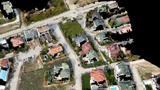
科潘,这是联合国教科文组织世界遗产名录,was once an important cultural and commercial centre on the south-eastern periphery of the Maya world. The landscape consists of alluvial terraces and foothills. The vegetation ranges from sub-tropical coverage in the valley to pine forests in the mountains. The environmental diversity within such a small area presents challenges in terms of locating and surveying archaeological structures (Figure 1).
Pedestrian Surveys
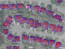
Since the late 19thcentury, many pedestrian surveys and excavations have given archaeologists an insight into 4,000 years of human occupation at Copan. Between 426 and 822 CE, a powerful Maya kingdom emerged during which the 17 kings that reigned in that period continually reshaped the city. Early investigations focused on the city’s main civic ceremonial zone – the Principal Group – comprising large temples and pyramids (Figure 2). From 1978 to 1980 the Copan Archaeological Project (PAC 1), led by French archaeologist Claude Baudez, surveyed and mapped an area of 24km2围绕主要群体。在1983年的项目报告中,考古学家威廉·法什(William Fash)和库尔特·朗(Kurt Long)以1:2,000的规模出版了24张地图,显示了3,000多个考古结构。从2006年到2008年,对PAC 1地图进行了数字化处理,地理化和丰富属性,以创建用于研究可访问性和可见性的GIS数据。
激光调查
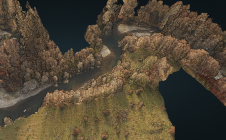
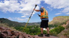
In 2000, the first Lidar survey over Copan was flown by the US Geological Survey (USGS) to assess flood and landslide damage following Hurricane Mitch. The data only captured the Principal Group. Within the present project Watershed Sciences Inc. (WSI) from Oregon, USA, collected Lidar data during four days in May 2013 using a Leica ALS50 Phase II system mounted in a Piper Aztec aircraft. This Lidar survey was aimed at: (1) identifying new archaeological sites, (2) evaluating site degradation/loss over time by comparing the Lidar data with existing maps, (3) assessing the pros and cons of Lidar for locating and mapping archaeological sites in an ecologically and topographically diverse environment, and (4) developing new datasets to be combined with other archaeological data and hosted in a 3D WebGIS. The targeted point density was at least 15 points/m2. This could be achieved through an across-track overlap of over 50%, effectively resulting in capturing the area twice. The average first-return density was 21.57 points/m2, and for ground return the number was 2.91 points/m2on average, locally depending on topography and vegetation density. Where vegetation was dense, the point density of ground returns reduced to less than one point/m2. Another challenge was that collapsed structures – mounds – are difficult to distinguish from natural topography in Lidar point clouds. At Copan, the distinction is even more difficult as constructions are incorporated into natural topography; mounds less than 0.25m in height proved particularly difficult to identify.
过滤
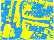
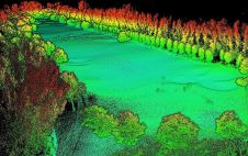
WSI delivered raw 3D points (LAS and ASCII), classified LAS data and raster data. Using proprietary automated and manual methods the 3D points were classified into bare earth, modern buildings and archaeological ruins. From these classified points, a bare earth model (DTM) and a DTM plus archaeological structures (DEM) were created (Figure 3). The filters distinguished bare earth from vegetation (DTM) but not bare earth from archaeological structures. The semi-automatic filters separated mounds from topographic features such as natural hills, but were not able to distinguish mounds lower than 80 centimetres from the natural terrain. The filters also removed This is typical of many Lidar filters that are customised ad-hoc to segment out vegetation and man-made structures. FBK refined and applied other filters based on landform and vegetation cover to extract a DTM without mounds and archaeological structures. Comparison between WSI’s classified data and PAC 1 data showed that 14% of the features originally classified as bare earth were actually mounds. A classification workflow based on plane identification, seed points and region growing enabled three classes to be identified: ground, building and vegetation (Figure 4). Points classified as structures were then compared with PAC 1 data and WSI data, revealing several new mounds ranging in height from 0.5m to 1m and some positional and orientation shifts in structures. Of the 521 sites mapped in the PAC 1 maps, 468 sites were relocated. The new filtering strategy resulted in new DTMs, DEMs and contour lines with 0.2m, 1m and 5m intervals. Next, these products were employed for field work and archaeological analysis. Added to the above products, terrestrial laser scans and photogrammetric 3D models of selected structures, architectural sculptures and monuments were produced and merged for online access. Methods used to identify unmapped features included hill shading, principal component analysis, slope gradient computation, modelling local relief and applying sky view factors (SVFs) which were calculated as the fraction of sky visible when viewed from the ground up. Slope and SVF worked best to delineate low-lying mounds, and SVF was best for identifying terraces.
Results
使用标准和新开发的方法从LiDAR数据中得出的产品使考古学家可以更新PAC 1地图。特别是,在PAC 1地图和激光雷达产品之间发现了五个关键差异:内部组成,位置,结构取向,结构大小和/或丘高。这些差异证明了LiDAR数据的有用性,不仅用于定位考古站点,而且还用于具有成本效益和时间效率的映射,尤其是在广阔的景观中。PAC 1的调查通过了一些考古遗址,因为土地所有者没有许可减少植被,有些地区太陡峭而无法安全进入。从LiDAR数据中鉴定出这些未映射的位点。虽然从LiDar数据中鉴定出可能是古老的一些地点实际上是现代的,例如从农田中清除的一堆石头或历史悠久的房屋基础,但现场工作证实了对18个新的考古丘的识别,它们也得到了映射。LiDAR数据还允许识别未塑造的农业露台,进一步的研究可能有助于扩大有关山谷古代农业系统的知识。大量长满的丘陵地形可以降低LiDar产品的准确性。进行地面检查使考古学家能够评估其准确性,但是不可能参观每个广阔景观的角落和裂缝。因此,与特定标准相关的精度的计算,例如地形和植被,可以帮助考古学家完善后处理方法并开发新的过滤器以提高准确性。
总结说
Various institutions have excavated at Copan since 1850. As a result, archaeological objects and documents are dispersed all around the world. Thanks to the MayaArch3D efforts, archaeologists can now use 2D and 3D WebGIS tools to bring distributed archaeological data together and collaborate online (Figure 5).
Authors
Dr Jennifer von Schwerin在德国波恩的德国考古研究所(DAI)的非欧洲文化考古委员会(DAI)委员会的研究研究员协调了Copan Lidar项目。
电子邮件:Jennifer.vonschwerin@dainst.de
希瑟·理查兹·里塞托(Heather Richards-Rissetto)博士is an assistant professor in anthropology and faculty fellow at the Center for Digital Research in the Humanities at the University of Nebraska-Lincoln, USA.
电子邮件:richards-rissetto@unl.edu
Fabio Remondino博士领导意大利特伦托FBK的3D光学计量单元。他目前是ISPRS技术委员会II“摄影测量”的总裁,Eurosdr委员会I“数据获取”总裁兼CIPA遗产文档副总裁。
电子邮件:remondino@fbk.eu
MayaArch3D
Funded by the German government,MayaArch3D是由德国考古研究所(DAI)的非欧洲文化考古委员会领导的合作和跨学科项目。该项目涉及海德堡大学(德国)的地理研究所,人类学系和内布拉斯加州林肯大学人文学科中心(美国),Bruno Kessler基金会的3D光学计量单位(特伦托(意大利)和洪都拉斯人类学与历史学院(IHAH)的FBK)。该项目旨在捕获Copan的Maya站点,并开发2D和3D WebGIS工具。这些工具可帮助考古学家在线整合,可视化和查询复杂的考古数据。
使您的收件箱更有趣。Add some geo.
Keep abreast of news, developments and technological advancement in the geomatics industry.
免费注册