如何获得最佳的精度和点云精度
We rarely stop to appreciate just how complex modern surveying technology is. Surveyors use the most advanced physics, with decades of experience, in every component. Consequently, in such complex systems, there are many sources of error. Luckily however, we can talk about these quite broadly to better understand the accuracy of our surveying. This article will discuss further some important points for obtaining survey and point cloud accuracy from a surveyor’s perspective.
IMU准确性
An IMU (inertial measurement unit) measures the intrinsic movement to which it is subjected. Typically using gyroscopic instruments and accelerometers the IMU will determine its acceleration and changes in its orientation. For surveyors therefore, an IMU is extremely important. This is because surveying typically is the observation of objects at a distance from oneself for the greatest convenience but the further away an object is, the less accurately its position can be known. Consider the diagram below; for all measurements there is an intrinsic error including in the angle changes measured by the IMU.
Taking a small angle approximation, the error in an objects position is simply the angular error x distance to the object. This means that a tiny angular error can easily lead to a very large discrepancy in a surveyed object’s position by being at a long range. A typical IMU for surveying such as the OxTS NAV650 IMU might have an accuracy of half a degree.
IMU对于导航目的也非常重要。本质上,IMU测量运动。这意味着测量师可以将其用作基本导航设备来跟踪IMU的移动方式。因此,可以使用高级IMU来输出必需方向信息,还可以使用IMU所在位置的信息。但是,所有仪器在其测量中表现出随机步行或漂移,这将对点云准确性产生负面影响。因此,仅IMU会迅速脱离其真正的位置,因为它可以衡量运动,并且不会定位位置。

GNSS本地化
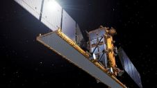
A GNSS (global navigation satellite system) system localises its position on the Earth using the constellations of satellites in orbit. Using the highly accurate timing information from these satellite signals, a GNSS receiver is able to determine its position to within much less than a meter on the Earth’s surface. By using a second receiver, often referred to as a base station, corrections can be calculated for how the signals from the satellites have been distorted in the atmosphere and this can increase the accuracy of the device to even a centimetre.
还有其他系统可用于本地化位置,但是当无法接收GNSS信号时,其中大多数系统仅限于大型基础架构环境,可以用作替代品,目前,在户外环境中没有真正的竞争对手。GNS在地球上给出了高度准确,精确的绝对定位,而许多替代品只能在无GNS本身的情况下提供相对定位。
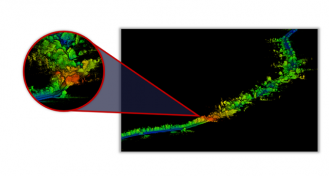
GNSSConstellations
有四个主要的GNSS satelli星座tes in use today. For a long time the Russian and US constellations, GLONASS and GPS, have been ubiquitously used but the European and Chinese constellations, Galileo and Beidou, are becoming increasingly widespread also (there are others also, for example QZSS). In general, accuracies using these individual constellations are similar, but a GNSS system can make the best use of all available data by using multiple, or all four, of these constellations combined. In the image shown below, you can see the trajectory of an INS system. The trajectory of a GPS only (blue) position trace and a GPS and GLONASS (red) trace is shown. As the vehicle has passed by some obstructive trees and buildings the satellite signals have been lost and position drift has occurred. In post-processing this is seen by a sudden jump in the position of the blue line, and it appears to be moving in the wrong lane. However, in the red line we see no such jump but a smooth trajectory in the correct place. This is because GNSS systems need a minimum number of satellites in order to provide optimal results. The more satellites, or the more constellations, the more reliable the position output will be especially in poor GNSS environments such as a city or town. Nowadays systems such as the OxTS xNAV650 are moving towards offering all four of these constellations as standard for the most reliable solution.
使您的收件箱更有趣。Add some geo.
Keep abreast of news, developments and technological advancement in the geomatics industry.
免费注册