布鲁斯基完成了英国和爱尔兰的调查季节
本文最初发表在Geomatics World.
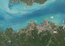
Aerial mapping company Bluesky has completed another survey season in the UK and Ireland. Capturing around 70,000 square kilometres of aerial photography – of which about 70% is high resolution – the total area flown equates to around twice the size of the Netherlands. This year was marked by using an innovative hybrid airborne sensor combining vertical and oblique imagery together with 3D laser scanning.
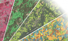
In addition to the true ortho photography, which is used to create 3D height models of the earth’s bare surface (Digital Terrain Models / DTM) and ground features including buildings and trees (Digital Surface Models / DSM), Bluesky has captured Colour Infrared imagery of the entire area. This CIR imagery can be used to create environmental maps which help determine the health and state of vegetation.
布鲁斯基还一直忙于使用世界上第一个混合机载传感器来捕获伦敦和其他城市的垂直和倾斜图像和激光雷达(光检测和范围)数据大都会城市地图计划。
城市地图
”,由于一般湿飞行eason, we have still managed to capture a significant amount of new imagery thanks to our diligent flight operations team who are constantly looking to maximize the flying windows available to us,” commented Rachel Tidmarsh, managing director of布鲁斯基国际.
In the UK, areas captured by Bluesky include London, Manchester, Birmingham, Oxford, Aberdeen, Kent, Cardiff and Vale of Glamorgan. The 2019 flying will be added to Bluesky’s extensive archive of imagery which is widely used by government organizations as part of the Aerial Photography for Great Britain (APGB) contract and multi-national blue-chip businesses.
Originally established in 1996 in the UK, Bluesky has in total captured millions of square kilometres of aerial survey data in more than 15 countries and this announcement builds on a period of significant expansion by Bluesky, whose international network includes offices in England, Northern Ireland, Republic of Ireland (EIRE) and the US, production facilities in the UK and India and flying bases in the UK, Ireland and America.
使您的收件箱更有趣。Add some geo.
Keep abreast of news, developments and technological advancement in the geomatics industry.
免费注册